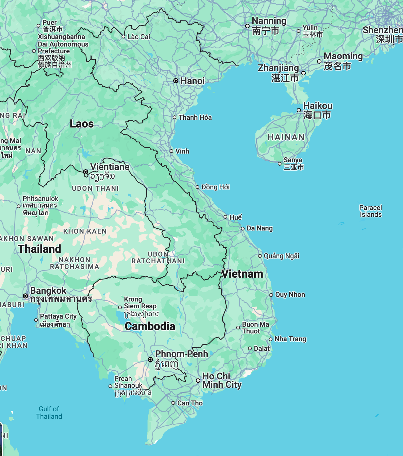
Map of Vietnam
Introduction to Vietnam

Vietnam is a land of natural beauty and cultural depth, stretching from the lush mountains of the north to the Mekong Delta in the south. With its diverse regions, thriving cities, and welcoming people, Vietnam is a top destination for travelers and real estate investors alike. The country is divided into three main regions: Northern, Central, and Southern Vietnam.
Exploring the Regions of Vietnam
Northern Vietnam
Hanoi
Vietnam’s capital is a vibrant mix of ancient temples and colonial architecture. Real estate prices range from $2,000–$4,000 per square meter for apartments in central districts. Discover houses for sale in Hanoi.
Ha Long Bay
Known for its emerald waters and limestone islands, Ha Long Bay is a UNESCO World Heritage Site. Properties near Ha Long Bay include vacation homes priced between $1,500–$2,500 per square meter. Explore real estate near Ha Long Bay.
Central Vietnam
Da Nang
A coastal city known for its sandy beaches and modern infrastructure. Apartments in Da Nang typically range from $1,800–$3,000 per square meter. Check out property market trends in Vietnam.
Hoi An
A charming town with well-preserved ancient buildings and a thriving expat community. Real estate options in Hoi An include traditional homes priced between $2,000–$3,500 per square meter. Search for houses for sale in Hoi An.
Southern Vietnam
Ho Chi Minh City
Formerly Saigon, this bustling city is Vietnam’s economic hub. Apartments in prime districts such as District 1 are priced between $3,000–$6,000 per square meter. Discover houses for sale in Ho Chi Minh City.
Mekong Delta
Known as the “Rice Bowl” of Vietnam, the Mekong Delta features floating markets and lush landscapes. Properties in the Mekong Delta are more affordable, ranging from $1,200–$2,500 per square meter. Explore houses for sale in the Mekong Delta.
Major Tourist Destinations
Vietnam boasts an array of must-see attractions, from the ancient town of Hoi An to the scenic rice terraces of Sapa. For those seeking adventure or relaxation, Vietnam has it all.
Airports and Accessibility
Interesting Facts and Key Information
- Vietnam is one of the fastest-growing economies in Southeast Asia.
- It is home to eight UNESCO World Heritage Sites.
- Vietnamese cuisine, including pho and banh mi, is celebrated worldwide.
- The country has a coastline stretching over 3,000 kilometers.
Here are 10 common questions and answers about maps of Vietnam:
1. What are the main regions of Vietnam?
Vietnam is divided into three main regions: Northern Vietnam, Central Vietnam, and Southern Vietnam. Each region offers unique landscapes, cultural attractions, and real estate opportunities.
2. What are the major cities shown on a map of Vietnam?
The major cities include Hanoi (capital in the north), Ho Chi Minh City (economic hub in the south), and Da Nang (central coastal city).
3. What natural landmarks are highlighted on a Vietnam map?
Prominent landmarks include Ha Long Bay, the Mekong Delta, Phong Nha-Ke Bang National Park, and the Central Highlands.
4. How can I use a map of Vietnam to plan travel?
A map helps identify key cities, airports (like Noi Bai in Hanoi and Tan Son Nhat in Ho Chi Minh City), major highways, and tourist spots, aiding in efficient trip planning.
5. What does a Vietnam real estate map show?
Real estate maps highlight property hotspots like Ho Chi Minh City, Hanoi, and coastal areas like Da Nang and Nha Trang, showing available residential and commercial properties.
6. Are Vietnam maps available online?
Yes, platforms like Google Maps, and websites like Vietnam Maps provide detailed interactive maps with travel routes and landmarks.
7. How detailed are maps of Vietnam’s provinces?
Maps can zoom in on Vietnam’s 58 provinces and 5 municipalities, showcasing local attractions, roads, and administrative boundaries.
8. Can maps show Vietnam’s UNESCO World Heritage Sites?
Yes, maps often highlight UNESCO sites like Ha Long Bay, Hoi An Ancient Town, My Son Sanctuary, and Phong Nha-Ke Bang National Park.
9. What is the scale of maps typically used for Vietnam?
Common map scales for Vietnam range from 1:1,000,000 for national overviews to 1:25,000 for city or regional details.
10. How is the geography of Vietnam depicted on maps?
Maps illustrate Vietnam’s long coastline, mountain ranges in the northwest, flat plains in the Mekong Delta, and diverse climates across regions.
Let me know if you’d like to incorporate these questions into your current project or require further customization!
Summary
Vietnam’s diverse regions offer endless opportunities for travelers and investors alike. Whether you’re exploring Hanoi’s historic streets, relaxing in Da Nang, or investing in a property in Ho Chi Minh City, Vietnam has something to captivate everyone.


